Geolocate

Screedy topographic map

Click on the map to display elevation.

About this map

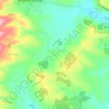
Name: Screedy topographic map, elevation, terrain.

Location: Screedy, Milverton, Somerset, England, TA4 1NH, United Kingdom (51.00216 -3.31581 51.04216 -3.27581)

Average elevation: 123 m

Minimum elevation: 65 m

Maximum elevation: 243 m

Gear up for your next adventure:

🦶Anti-Blister Balm - Prevents friction and hotspots during long ascents
🧰Emergency Multi-Tool - Compact multi-tool for outdoor survival
🦯Trekking Poles - Reduced impact on joints for steep topographic climbs
🧥Insulated Jacket - Keep warm in cold outdoor conditions
🧥Ultralight Puffy Jacket - Maximum warmth that packs down to the size of an orange

As an Amazon Associate, this site earns from qualifying purchases at no extra cost to you.