
Chiusdino topographic map
Interactive map
Click on the map to display elevation.
About this map
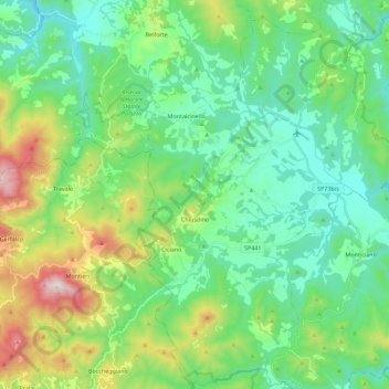
Name: Chiusdino topographic map, elevation, terrain.
Location: Chiusdino, Siena, Toscane, Italie (43.08320 11.05014 43.24691 11.22355)
Average elevation: 434 m
Minimum elevation: 214 m
Maximum elevation: 1,045 m
Other topographic maps
Click on a map to view its topography, its elevation and its terrain.
Podere Rossi
Podere Rossi, Chiusdino, SI, Toscane, Italie
Average elevation: 285 m