Geolocate

Stoke Prior topographic map

Click on the map to display elevation.

About this map

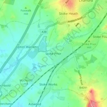
Name: Stoke Prior topographic map, elevation, terrain.

Location: Stoke Prior, Bromsgrove, Worcestershire, England, B60 4NA, United Kingdom (52.28248 -2.10593 52.32248 -2.06593)

Average elevation: 68 m

Minimum elevation: 45 m

Maximum elevation: 129 m

Other topographic maps

Click on a map to view its topography, its elevation and its terrain.

Romsley CP

United Kingdom > England > Worcestershire > Bromsgrove

Average elevation: 205 m

Wythall CP

United Kingdom > England > Worcestershire > Bromsgrove

Average elevation: 155 m

Wythall CP

United Kingdom > England > Worcestershire > Bromsgrove

Average elevation: 155 m

Wythall CP

United Kingdom > England > Worcestershire > Bromsgrove

Average elevation: 155 m

Clent

United Kingdom > England > Worcestershire > Bromsgrove

Because of the hilly topography of the parish the village consists of several distinct hamlets. These are Upper Clent (Clatterbach and the area around the parish church of St. Leonard), Lower Clent, Holy Cross, Adams Hill and Walton Pool. The Civil Parish of Clent also included part of the village of West…

Average elevation: 184 m

Romsley CP

United Kingdom > England > Worcestershire > Bromsgrove

Average elevation: 205 m

Wythall CP

United Kingdom > England > Worcestershire > Bromsgrove

Average elevation: 155 m

Gear up for your next adventure:

🦟Insect Repellent - Keep mosquitoes and black flies away in wooded areas
🕯️Camping Lantern - Illuminates your entire campsite with high-efficiency LEDs
🧴Sunscreen SPF - Broad-spectrum sunscreen for outdoor activities
🧥Softshell Hiking Jacket - The perfect balance of wind protection and breathability
🕶️Polarized Sunglasses - Protect your eyes with durable polarized lenses

As an Amazon Associate, this site earns from qualifying purchases at no extra cost to you.