Geolocate

Maidstone topographic map

Click on the map to display elevation.

About this map

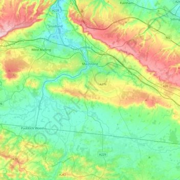
Name: Maidstone topographic map, elevation, terrain.

Location: Maidstone, Kent, England, United Kingdom (51.13395 0.37810 51.33874 0.79644)

Average elevation: 70 m

Minimum elevation: -3 m

Maximum elevation: 230 m

Other topographic maps

Click on a map to view its topography, its elevation and its terrain.

Brabourne Lees

United Kingdom > England > Kent > Ashford

Average elevation: 73 m

Chalk

United Kingdom > England > Kent > Gravesham

Average elevation: 27 m

Seasalter

United Kingdom > England > Kent > Canterbury

Average elevation: 12 m

Harbledown

United Kingdom > England > Kent > Canterbury

Average elevation: 41 m

Five Oak Green

United Kingdom > England > Kent > Tunbridge Wells

Average elevation: 28 m

Repton

United Kingdom > England > Kent > Ashford

Average elevation: 55 m

Sundries

United Kingdom > England > Kent > Borough of Swale > Bapchild

Average elevation: 33 m

Gear up for your next adventure:

🚲Bike Repair Kit - Essential tools for on-trail mechanical issues
🔋Emergency Crank Radio - Weather alerts and power without needing batteries
🎒Hiking Backpack - Lightweight and ergonomic backpacks for day hikes or multi-day treks
🥾Hiking Shoes - Durable and comfortable shoes for trail hiking
Camping Tent - Weather-resistant tents suitable for 2 to 6 people

As an Amazon Associate, this site earns from qualifying purchases at no extra cost to you.