
Make a donation
Gear up for your next adventure:
As an Amazon Associate, this site earns from qualifying purchases at no extra cost to you.
Chattahoochee County topographic map
Click on the map to display elevation.
Make a donation
Gear up for your next adventure:
As an Amazon Associate, this site earns from qualifying purchases at no extra cost to you.
About this map
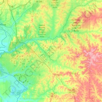
Name: Chattahoochee County topographic map, elevation, terrain.
Location: Chattahoochee County, Georgia, United States (32.22083 -85.00730 32.53621 -84.63729)
Average elevation: 123 m
Minimum elevation: 57 m
Maximum elevation: 232 m
Make a donation
Gear up for your next adventure:
As an Amazon Associate, this site earns from qualifying purchases at no extra cost to you.
Other topographic maps
Click on a map to view its topography, its elevation and its terrain.
Fort Benning
United States > Georgia > Chattahoochee County > Chattahoochee County
Average elevation: 95 m
East Main Post
United States > Georgia > Chattahoochee County > Chattahoochee County
Average elevation: 100 m
Montgomery Hill
United States > Georgia > Chattahoochee County > Chattahoochee County
Average elevation: 96 m
Make a donation
Gear up for your next adventure:
As an Amazon Associate, this site earns from qualifying purchases at no extra cost to you.