Geolocate

North Weston topographic map

Click on the map to display elevation.

About this map

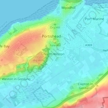
Name: North Weston topographic map, elevation, terrain.

Location: North Weston, Portishead, North Somerset, England, BS20 6RF, United Kingdom (51.45404 -2.79530 51.49404 -2.75530)

Average elevation: 31 m

Minimum elevation: 0 m

Maximum elevation: 140 m

Other topographic maps

Click on a map to view its topography, its elevation and its terrain.

Gear up for your next adventure:

🔥Emergency Fire Starter - Reliable ignition source for all weather conditions
🎒Hiking Daypack - Lightweight and durable backpacks for day trips and excursions
🎒Fully Waterproof Backpack - Total protection for photography gear and electronics
🎒Hiking Backpack - Lightweight and ergonomic backpacks for day hikes or multi-day treks
🥾Light Trekking Boots - Supportive boots for multi-day treks

As an Amazon Associate, this site earns from qualifying purchases at no extra cost to you.