
Chaddesley Corbett topographic map
Click on the map to display elevation.
About this map
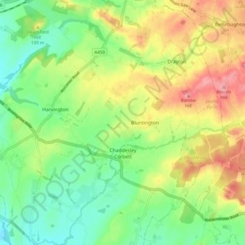
Name: Chaddesley Corbett topographic map, elevation, terrain.
Average elevation: 92 m
Minimum elevation: 47 m
Maximum elevation: 154 m
Other topographic maps
Click on a map to view its topography, its elevation and its terrain.
Stourport Historic Canal Basins
United Kingdom > England > Worcestershire > Wyre Forest > Stourport-on-Severn > Wilden
Average elevation: 33 m
River Severn
United Kingdom > England > Worcestershire > Wyre Forest > Stourport-on-Severn
Average elevation: 45 m
Shatterford
United Kingdom > England > Worcestershire > Wyre Forest > Upper Arley
Average elevation: 124 m
Low Habberley
United Kingdom > England > Worcestershire > Wyre Forest > Ferndale
Average elevation: 85 m