
Kingsbury CP topographic map
Interactive map
Click on the map to display elevation.
About this map
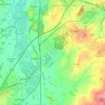
Name: Kingsbury CP topographic map, elevation, terrain.
Average elevation: 88 m
Minimum elevation: 47 m
Maximum elevation: 160 m
Other topographic maps
Click on a map to view its topography, its elevation and its terrain.
Kingsbury
United Kingdom > England > North Warwickshire > Kingsbury
Kingsbury, North Warwickshire, Warwickshire, West Midlands, England, B78 2LP, United Kingdom
Average elevation: 86 m
Gilson
United Kingdom > England > North Warwickshire > Coleshill > Gilson
Gilson, Coleshill CP, Coleshill, North Warwickshire, Warwickshire, West Midlands, England, B46 1LN, United Kingdom
Average elevation: 82 m
River Cole
United Kingdom > England > North Warwickshire
River Cole, North Warwickshire, Warwickshire, West Midlands, England, B46 1HE, United Kingdom
Average elevation: 79 m
Caldecote CP
United Kingdom > England > North Warwickshire
Caldecote CP, North Warwickshire, Warwickshire, West Midlands, England, United Kingdom
Average elevation: 86 m
Arley CP
United Kingdom > England > North Warwickshire
Arley CP, North Warwickshire, Warwickshire, West Midlands, England, United Kingdom
Average elevation: 138 m
Austrey
United Kingdom > England > North Warwickshire > Austrey
Austrey, North Warwickshire, Warwickshire, West Midlands, England, CV9 3EX, United Kingdom
Average elevation: 91 m
Kingsbury Water Park
United Kingdom > England > North Warwickshire
Kingsbury Water Park, Kingsbury CP, North Warwickshire, Warwickshire, West Midlands, England, United Kingdom
Average elevation: 69 m
Atherstone CP
United Kingdom > England > North Warwickshire
Atherstone CP, North Warwickshire, Warwickshire, West Midlands, England, United Kingdom
Average elevation: 85 m
Polesworth CP
United Kingdom > England > North Warwickshire
Polesworth CP, North Warwickshire, Warwickshire, West Midlands, England, United Kingdom
Average elevation: 76 m