
Make a donation
Gear up for your next adventure:
As an Amazon Associate, this site earns from qualifying purchases at no extra cost to you.
Popasna topographic map
Click on the map to display elevation.
Make a donation
Gear up for your next adventure:
As an Amazon Associate, this site earns from qualifying purchases at no extra cost to you.
About this map
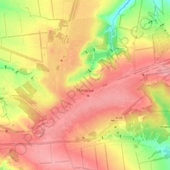
Name: Popasna topographic map, elevation, terrain.
Average elevation: 228 m
Minimum elevation: 160 m
Maximum elevation: 267 m
Make a donation
Gear up for your next adventure:
As an Amazon Associate, this site earns from qualifying purchases at no extra cost to you.
Other topographic maps
Click on a map to view its topography, its elevation and its terrain.
Stelmakhivka
The village is located near the border of Luhansk and Kharkiv Oblasts. 20 kilometers from Svatove and 23 kilometers from the urban settlement of Borova. Administratively, the village was arranged into the Svatove Raion in 2020. The elevation is 146 meters.
Average elevation: 169 m
Make a donation
Gear up for your next adventure:
As an Amazon Associate, this site earns from qualifying purchases at no extra cost to you.