Geolocate

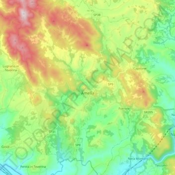
Amelia topographic map

Click on the map to display elevation.

Amelia

Amelia is situated 24 kilometres (15 mi) from Terni and 13 kilometres (8.1 mi) from Narni on the slope of a hill at an elevation of about 406 metres (1,332 ft) above sea level, between the valley of the Tiber and that of the Nera, not far from the point where these rivers meet. The town occupies a position with a difference in elevation of about 75 metres (246 ft) across the settlement.

Wikipedia (CC-BY-SA 3.0)

About this map

Name: Amelia topographic map, elevation, terrain.

Location: Amelia, Terni, Umbria, 05022, Italy (42.48592 12.30668 42.63005 12.47903)

Average elevation: 324 m

Minimum elevation: 50 m

Maximum elevation: 828 m

Other topographic maps

Click on a map to view its topography, its elevation and its terrain.

Ponte

Italy > Umbria > Terni > Castel dell'Aquila

Average elevation: 383 m

Marmore

Italy > Umbria > Terni > Terni

Average elevation: 435 m

Tenaglie

Italy > Umbria > Terni > Montecchio

Average elevation: 308 m

San Marino

Italy > Umbria > Terni > San Venanzo

Average elevation: 510 m

Archileggi

Italy > Umbria > Terni > Amelia

Average elevation: 303 m

Osteria di Biagio

Italy > Umbria > Terni > Orvieto

Average elevation: 558 m

Gear up for your next adventure:

🧴Waterproofing Spray - Restore the DWR coating on jackets and tents
🎒Fully Waterproof Backpack - Total protection for photography gear and electronics
🥤Collapsible Travel Cup - Saves space and weight in your mess kit
🧤Insulated Winter Gloves - Heavy-duty protection for sub-zero Canadian adventures
🧥Softshell Jacket - Windproof and breathable jacket for hiking

As an Amazon Associate, this site earns from qualifying purchases at no extra cost to you.