Geolocate

Xiangzhou County topographic map

Click on the map to display elevation.

About this map
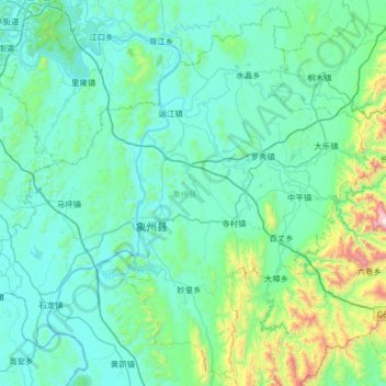
Name: Xiangzhou County topographic map, elevation, terrain.

Location: Xiangzhou County, Laibin, Guangxi, China (23.73165 109.42353 24.30437 110.07456)

Average elevation: 246 m

Minimum elevation: 40 m

Maximum elevation: 1,767 m

Other topographic maps

Click on a map to view its topography, its elevation and its terrain.

Jinji

China > Guangxi > Laibin

Average elevation: 79 m

Leishan

China > Guangxi > Laibin

Average elevation: 269 m

Shizuo

China > Guangxi > Laibin

Average elevation: 169 m

Wandai

China > Guangxi > Laibin

Average elevation: 227 m

Guban

China > Guangxi > Laibin

Average elevation: 123 m

Gear up for your next adventure:

🔋Lithium AA Batteries - Long-lasting power that performs in extreme cold
🧢Sun Protection Cap - Breathable cap to protect from sun exposure
🦟Insect Repellent - Keep mosquitoes and black flies away in wooded areas
🔦LED Flashlight - Powerful and long-lasting flashlight for camping and emergencies
🔥Emergency Fire Starter - Reliable ignition source for all weather conditions

As an Amazon Associate, this site earns from qualifying purchases at no extra cost to you.