Geolocate

Skudai topographic map

Click on the map to display elevation.

About this map
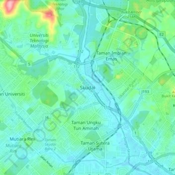
Name: Skudai topographic map, elevation, terrain.

Location: Skudai, Iskandar Puteri, Johor Bahru, Johor, 81210, Malaysia (1.49697 103.62210 1.57697 103.70210)

Average elevation: 29 m

Minimum elevation: 2 m

Maximum elevation: 149 m

Other topographic maps

Click on a map to view its topography, its elevation and its terrain.
Sungai Melayu

Malaysia > Johor > Iskandar Puteri

Average elevation: 15 m

Sungai Sekudai

Malaysia > Johor > Iskandar Puteri

Average elevation: 14 m

Pulai River

Malaysia > Johor > Iskandar Puteri

Average elevation: 12 m

Tebrau River

Malaysia > Johor > Iskandar Puteri

Average elevation: 34 m

Kampung Sepakat Baru

Malaysia > Johor > Iskandar Puteri

Average elevation: 23 m

Tebrau River

Malaysia > Johor > Iskandar Puteri

Average elevation: 34 m

Tasik Hati

Malaysia > Johor > Iskandar Puteri > Pulai

Average elevation: 26 m

Aspira LakeHomes

Malaysia > Johor > Iskandar Puteri

Average elevation: 27 m

Gear up for your next adventure:

🛁Quick-Dry Microfiber Towel - Space-saving towel that dries rapidly on the move
🧥Softshell Jacket - Windproof and breathable jacket for hiking
🧢Hiking Hat - Sun-protective and breathable hats for long treks
🧥Fleece Jacket - Warm and lightweight jacket for layering
🕶️Polarized Sunglasses - Reduces glare from snow and water at high elevations

As an Amazon Associate, this site earns from qualifying purchases at no extra cost to you.