Geolocate

Malfa topographic map

Click on the map to display elevation.

About this map

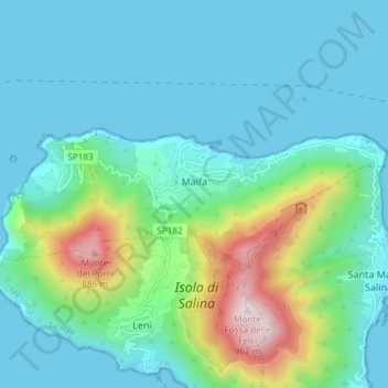
Name: Malfa topographic map, elevation, terrain.

Location: Malfa, Messina, Sicily, 98050, Italy (38.56418 14.79813 38.58398 14.87243)

Average elevation: 188 m

Minimum elevation: 0 m

Maximum elevation: 941 m

Other topographic maps

Click on a map to view its topography, its elevation and its terrain.

Castel di Tusa

Italy > Sicily > Messina

Average elevation: 96 m

Monte Serro

Italy > Sicily > Messina > Messina

Average elevation: 92 m

Sperone

Italy > Sicily > Messina > Messina

Average elevation: 56 m

Messina

Italy > Sicily > Messina > Messina

Average elevation: 180 m

Gear up for your next adventure:

🥾Mountain Hiking Boots - High-traction boots for rocky terrain
🥾Lightweight Hiking Shoes - Comfortable shoes for day hikes
🥾Trail Hiking Shoes - Durable shoes designed for rugged trails
💧Hydration Bladder - Hands-free hydration solution for long treks
🧰Multitool Knife - Compact and versatile tool for outdoor use

As an Amazon Associate, this site earns from qualifying purchases at no extra cost to you.