Geolocate

Loree topographic map

Click on the map to display elevation.

About this map

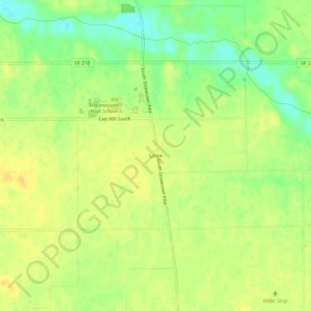
Name: Loree topographic map, elevation, terrain.

Location: Loree, Miami County, Indiana, 46914, United States (40.62560 -86.07805 40.66560 -86.03805)

Average elevation: 246 m

Minimum elevation: 229 m

Maximum elevation: 255 m

Other topographic maps

Click on a map to view its topography, its elevation and its terrain.

Mexico

United States > Indiana > Miami County

Average elevation: 222 m

Amboy

United States > Indiana > Miami County

Average elevation: 251 m

Bunker Hill

United States > Indiana > Miami County

Average elevation: 244 m

Maconaquah Park

United States > Indiana > Miami County > Peru > South Peru

Average elevation: 214 m

Gear up for your next adventure:

👟Leg Gaiters - Keep debris, mud, and snow out of your boots
🧴Waterproofing Spray - Restore the DWR coating on jackets and tents
🦶Hiking Shoe Insoles - Added support for high arches and long days on feet
🧼Biodegradable Camp Soap - Environmentally friendly cleaning for gear and body
📷Outdoor Action Camera - Capture high-elevation views and rugged adventures

As an Amazon Associate, this site earns from qualifying purchases at no extra cost to you.