Geolocate

Cuzco topographic map

Click on the map to display elevation.

About this map

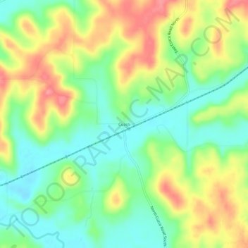
Name: Cuzco topographic map, elevation, terrain.

Location: Cuzco, Dubois County, Indiana, United States (38.45505 -86.74277 38.49505 -86.70277)

Average elevation: 181 m

Minimum elevation: 144 m

Maximum elevation: 229 m

Other topographic maps

Click on a map to view its topography, its elevation and its terrain.

Huntingburg

United States > Indiana > Dubois County

Average elevation: 148 m

Jasper

United States > Indiana > Dubois County

Average elevation: 151 m

Gear up for your next adventure:

🧭Orienteering Kit - Tools for map reading and navigation in the wild
🧭GPS Outdoor Watch - Smart watch for navigation and fitness tracking in nature
🧦Crew Hiking Socks - Comfortable socks for long-distance hikes
🥾Waterproof Hiking Shoes - Durable shoes for wet and rugged trails
🥾Approach Shoes - Shoes designed for climbing approaches and rugged trails

As an Amazon Associate, this site earns from qualifying purchases at no extra cost to you.