Geolocate

Jasper topographic map

Click on the map to display elevation.

About this map

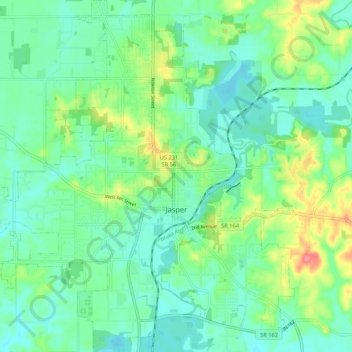
Name: Jasper topographic map, elevation, terrain.

Location: Jasper, Dubois County, Indiana, 47546, United States (38.35747 -86.99389 38.44073 -86.89525)

Average elevation: 151 m

Minimum elevation: 131 m

Maximum elevation: 200 m

Other topographic maps

Click on a map to view its topography, its elevation and its terrain.

Cuzco

United States > Indiana > Dubois County

Average elevation: 181 m

Thales

United States > Indiana > Dubois County

Average elevation: 184 m

Hillham

United States > Indiana > Dubois County

Average elevation: 208 m

Celestine

United States > Indiana > Dubois County

Average elevation: 185 m

Kellerville

United States > Indiana > Dubois County

Average elevation: 181 m

Jasper

United States > Indiana > Dubois County > Jasper

Average elevation: 150 m

Gear up for your next adventure:

🛰️Satellite Messenger - Emergency communication for areas with no cell service
🧭GPS Tracker - Track your location in remote areas safely
🧢Sun Hat - Wide-brim hat for sun protection
🥾Waterproof Hiking Shoes - Durable shoes for wet and rugged trails
🧭GPS Outdoor Watch - Smart watch for navigation and fitness tracking in nature

As an Amazon Associate, this site earns from qualifying purchases at no extra cost to you.