
Make a donation
Gear up for your next adventure:
As an Amazon Associate, this site earns from qualifying purchases at no extra cost to you.
Quevedo topographic map
Click on the map to display elevation.
Make a donation
Gear up for your next adventure:
As an Amazon Associate, this site earns from qualifying purchases at no extra cost to you.
Quevedo
Quevedo es una ciudad ecuatoriana; cabecera cantonal del Cantón Quevedo, así como la urbe más grande y poblada de la Provincia de Los Ríos. Se localiza al centro de la región litoral del Ecuador, en una extensa llanura atravesada por el río Quevedo, a una altitud de 74 m s. n. m. y con un clima lluvioso tropical de 25,2 °C en promedio.
Make a donation
Gear up for your next adventure:
As an Amazon Associate, this site earns from qualifying purchases at no extra cost to you.
About this map
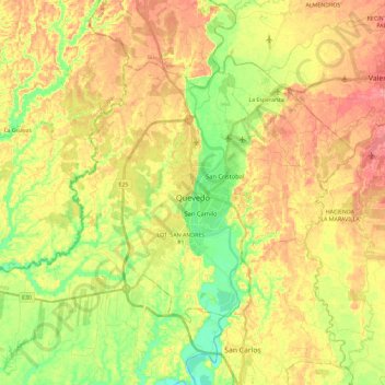
Name: Quevedo topographic map, elevation, terrain.
Location: Quevedo, Los Ríos, Ecuador (-1.09972 -79.61665 -0.94350 -79.38539)
Average elevation: 75 m
Minimum elevation: 29 m
Maximum elevation: 119 m
Make a donation
Gear up for your next adventure:
As an Amazon Associate, this site earns from qualifying purchases at no extra cost to you.
Other topographic maps
Click on a map to view its topography, its elevation and its terrain.
Make a donation
Gear up for your next adventure:
As an Amazon Associate, this site earns from qualifying purchases at no extra cost to you.
Área Verde en Ladera
Ecuador > Los Ríos > Quevedo > Quevedo > LOT. KARINA Mz. "B"
Average elevation: 65 m