
Thank you for supporting this site ❤️
Make a donation
Make a donation
Gear up for your next adventure:
As an Amazon Associate, this site earns from qualifying purchases at no extra cost to you.
Cañalito topographic map
Click on the map to display elevation.
Thank you for supporting this site ❤️
Make a donation
Make a donation
Gear up for your next adventure:
As an Amazon Associate, this site earns from qualifying purchases at no extra cost to you.
About this map
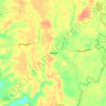
Name: Cañalito topographic map, elevation, terrain.
Location: Cañalito, Quevedo, Los Ríos, 120304, Ecuador (-1.04957 -79.42815 -1.00957 -79.38815)
Average elevation: 86 m
Minimum elevation: 56 m
Maximum elevation: 102 m
Thank you for supporting this site ❤️
Make a donation
Make a donation
Gear up for your next adventure:
As an Amazon Associate, this site earns from qualifying purchases at no extra cost to you.
Other topographic maps
Click on a map to view its topography, its elevation and its terrain.
Área Verde en Ladera
Ecuador > Los Ríos > Quevedo > Quevedo > LOT. KARINA Mz. "B"
Average elevation: 65 m