Geolocate

Elizabethtown topographic map

Click on the map to display elevation.

About this map

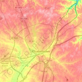
Name: Elizabethtown topographic map, elevation, terrain.

Location: Elizabethtown, Hardin County, Kentucky, 42701, United States (37.64993 -85.94766 37.76760 -85.82020)

Average elevation: 241 m

Minimum elevation: 151 m

Maximum elevation: 283 m

Other topographic maps

Click on a map to view its topography, its elevation and its terrain.

Eastview

United States > Kentucky > Hardin County

Average elevation: 231 m

Rineyville

United States > Kentucky > Hardin County

Average elevation: 242 m

Gaffey Heights

United States > Kentucky > Hardin County

Average elevation: 218 m

Limp

United States > Kentucky > Hardin County

Average elevation: 211 m

Cecil Hill

United States > Kentucky > Hardin County

Average elevation: 230 m

Kraft

United States > Kentucky > Hardin County

Average elevation: 247 m

West Point

United States > Kentucky > Hardin County > West Point

Average elevation: 169 m

Gear up for your next adventure:

🧭GPS Tracker - Track your location in remote areas safely
🧴Sunscreen SPF - Broad-spectrum sunscreen for outdoor activities
🧤Rechargeable Heated Gloves - Extreme warmth for Canadian winter expeditions
🔋Solar Power Bank - Keep your GPS and devices charged during long outdoor trips
🧭Orienteering Kit - Tools for map reading and navigation in the wild

As an Amazon Associate, this site earns from qualifying purchases at no extra cost to you.