Geolocate

Rantau Bayur topographic map

Click on the map to display elevation.

About this map

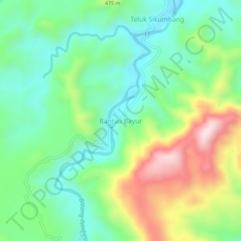
Name: Rantau Bayur topographic map, elevation, terrain.

Location: Rantau Bayur, Merangin, Jambi, Sumatra, Indonesia (-2.34297 102.05603 -2.30297 102.09603)

Average elevation: 336 m

Minimum elevation: 180 m

Maximum elevation: 640 m

Other topographic maps

Click on a map to view its topography, its elevation and its terrain.

Air Tembesi

Indonesia > Jambi > Merangin > Koto Teguh

Average elevation: 1,176 m

Batang Tantan

Indonesia > Jambi > Merangin

Average elevation: 150 m

Sungai Keruh

Indonesia > Jambi > Merangin > Rantau Kermas

Average elevation: 1,194 m

Sungai Putih

Indonesia > Jambi > Merangin > Sungai Putih

Average elevation: 122 m

Gear up for your next adventure:

Camping Groundsheet - Protect your tent from moisture and dirt
🔥Camping Stove - Portable stoves to cook outdoors with ease
👟Sport Hiking Sandals - Breathable footwear for water crossings and camp rest
💡Portable Camping Lamp - Rechargeable lamp for campsite lighting
🥾Waterproof Trail Shoes - Shoes designed to handle wet terrain

As an Amazon Associate, this site earns from qualifying purchases at no extra cost to you.