Geolocate

Kalofer topographic map

Click on the map to display elevation.

About this map

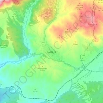
Name: Kalofer topographic map, elevation, terrain.

Location: Kalofer, Karlovo, Plovdiv, Bulgaria (42.57227 24.93379 42.65227 25.01379)

Average elevation: 643 m

Minimum elevation: 400 m

Maximum elevation: 1,119 m

Other topographic maps

Click on a map to view its topography, its elevation and its terrain.

Южен

Bulgaria > Plovdiv

Average elevation: 173 m

Източен

Bulgaria > Plovdiv

Average elevation: 159 m

Hisaria

Bulgaria > Plovdiv

Average elevation: 524 m

Южен

Bulgaria > Plovdiv

Average elevation: 173 m

Централен

Bulgaria > Plovdiv

Average elevation: 168 m

Gear up for your next adventure:

🏃Hydration Running Vest - Carry water and maps close to your body for speed
🧊Insulated Water Bottle - Keeps drinks cold in summer and prevents freezing in winter
🥤Collapsible Travel Cup - Saves space and weight in your mess kit
🛰️Satellite Messenger - Emergency communication for areas with no cell service
🦟Insect Repellent - Keep mosquitoes and black flies away in wooded areas

As an Amazon Associate, this site earns from qualifying purchases at no extra cost to you.