
Make a donation
Gear up for your next adventure:
As an Amazon Associate, this site earns from qualifying purchases at no extra cost to you.
Maasen topographic map
Click on the map to display elevation.
Make a donation
Gear up for your next adventure:
As an Amazon Associate, this site earns from qualifying purchases at no extra cost to you.
About this map
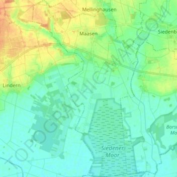
Name: Maasen topographic map, elevation, terrain.
Average elevation: 41 m
Minimum elevation: 31 m
Maximum elevation: 63 m
Make a donation
Gear up for your next adventure:
As an Amazon Associate, this site earns from qualifying purchases at no extra cost to you.
Other topographic maps
Click on a map to view its topography, its elevation and its terrain.
Hohnholz
Deutschland > Niedersachsen > Landkreis Diepholz > Twistringen > Abbenhausen
Average elevation: 48 m
Make a donation
Gear up for your next adventure:
As an Amazon Associate, this site earns from qualifying purchases at no extra cost to you.
Make a donation
Gear up for your next adventure:
As an Amazon Associate, this site earns from qualifying purchases at no extra cost to you.
Fesenfeld
Deutschland > Niedersachsen > Landkreis Diepholz > Bassum > Nordwohlde
Average elevation: 33 m
Make a donation
Gear up for your next adventure:
As an Amazon Associate, this site earns from qualifying purchases at no extra cost to you.
Otersen
Deutschland > Niedersachsen > Landkreis Diepholz > Bruchhausen-Vilsen > Süstedt
Average elevation: 50 m
Üssinghausen
Deutschland > Niedersachsen > Landkreis Diepholz > Twistringen > Abbenhausen
Average elevation: 50 m
Make a donation
Gear up for your next adventure:
As an Amazon Associate, this site earns from qualifying purchases at no extra cost to you.
Make a donation
Gear up for your next adventure:
As an Amazon Associate, this site earns from qualifying purchases at no extra cost to you.
Make a donation
Gear up for your next adventure:
As an Amazon Associate, this site earns from qualifying purchases at no extra cost to you.
Tuschendorf
Deutschland > Niedersachsen > Landkreis Diepholz > Martfeld > Tuschendorf
Average elevation: 14 m
Make a donation
Gear up for your next adventure:
As an Amazon Associate, this site earns from qualifying purchases at no extra cost to you.
Scholen
Deutschland > Niedersachsen > Landkreis Diepholz > Bruchhausen-Vilsen > Scholen
Average elevation: 56 m
Ellinghausen
Deutschland > Niedersachsen > Landkreis Diepholz > Twistringen > Heiligenloh
Average elevation: 50 m
Make a donation
Gear up for your next adventure:
As an Amazon Associate, this site earns from qualifying purchases at no extra cost to you.