
Make a donation
Gear up for your next adventure:
As an Amazon Associate, this site earns from qualifying purchases at no extra cost to you.
Bocksgründen topographic map
Click on the map to display elevation.
Make a donation
Gear up for your next adventure:
As an Amazon Associate, this site earns from qualifying purchases at no extra cost to you.
About this map
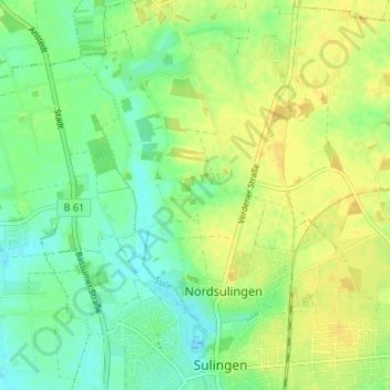
Name: Bocksgründen topographic map, elevation, terrain.
Average elevation: 54 m
Minimum elevation: 42 m
Maximum elevation: 64 m
Make a donation
Gear up for your next adventure:
As an Amazon Associate, this site earns from qualifying purchases at no extra cost to you.
Other topographic maps
Click on a map to view its topography, its elevation and its terrain.
27232
Deutschland > Niedersachsen > Landkreis Diepholz > Sulingen > Klein Lessen > Dahlskamp
Average elevation: 44 m
Groß Lessen
Deutschland > Niedersachsen > Landkreis Diepholz > Sulingen > Groß Lessen
Average elevation: 42 m
Make a donation
Gear up for your next adventure:
As an Amazon Associate, this site earns from qualifying purchases at no extra cost to you.