
Make a donation
Gear up for your next adventure:
As an Amazon Associate, this site earns from qualifying purchases at no extra cost to you.
Moerbeke topographic map
Click on the map to display elevation.
Make a donation
Gear up for your next adventure:
As an Amazon Associate, this site earns from qualifying purchases at no extra cost to you.
Moerbeke
Moerbeke ligt op een hoogte van 15-69 meter. De plaats zelf ligt op 34 meter hoogte. De gemeente wordt doorstroomd door de Grande Steenbecque (Grote Steenbeek) die vanuit het noorden in zuidelijke richting naar de vallei van de Leie vloeit.
Make a donation
Gear up for your next adventure:
As an Amazon Associate, this site earns from qualifying purchases at no extra cost to you.
About this map
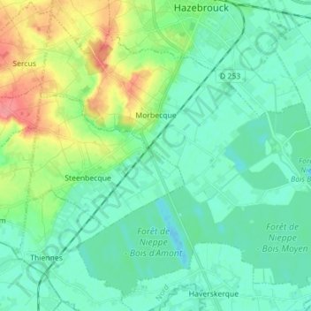
Name: Moerbeke topographic map, elevation, terrain.
Average elevation: 27 m
Minimum elevation: 10 m
Maximum elevation: 76 m
Make a donation
Gear up for your next adventure:
As an Amazon Associate, this site earns from qualifying purchases at no extra cost to you.
Other topographic maps
Click on a map to view its topography, its elevation and its terrain.
Schelde
Frankrijk > Hauts-de-France > Noorderdepartement > Thun-l'Évêque
Doorheen het grootste deel van het Pleistoceen stroomde de Schelde nog steeds richting het noordnoordoosten, uitmondend in de zich opvullende baai ter hoogte van de ruime regio rond Den Bosch. In het stroomgebied van de Bovenschelde, voltrok zich tijdens de grillige klimatologische omstandigheden van het…
Average elevation: 51 m
Make a donation
Gear up for your next adventure:
As an Amazon Associate, this site earns from qualifying purchases at no extra cost to you.
Make a donation
Gear up for your next adventure:
As an Amazon Associate, this site earns from qualifying purchases at no extra cost to you.
Maresquel
Frankrijk > Hauts-de-France > Noorderdepartement > Templeuve-en-Pévèle
Average elevation: 42 m