
Make a donation
Gear up for your next adventure:
As an Amazon Associate, this site earns from qualifying purchases at no extra cost to you.
Schelde topographic map
Click on the map to display elevation.
Make a donation
Gear up for your next adventure:
As an Amazon Associate, this site earns from qualifying purchases at no extra cost to you.
Schelde
Doorheen het grootste deel van het Pleistoceen stroomde de Schelde nog steeds richting het noordnoordoosten, uitmondend in de zich opvullende baai ter hoogte van de ruime regio rond Den Bosch. In het stroomgebied van de Bovenschelde, voltrok zich tijdens de grillige klimatologische omstandigheden van het Pleistoceen echter een geomorfologisch interessant fenomeen met de Schelde in de hoofdrol: terrasvorming. Het geaccidenteerde reliëf in de Vlaamse Ardennen is voor een niet onbelangrijk deel te wijten aan deze terrassen.
Make a donation
Gear up for your next adventure:
As an Amazon Associate, this site earns from qualifying purchases at no extra cost to you.
About this map
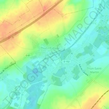
Name: Schelde topographic map, elevation, terrain.
Average elevation: 51 m
Minimum elevation: 34 m
Maximum elevation: 75 m
Make a donation
Gear up for your next adventure:
As an Amazon Associate, this site earns from qualifying purchases at no extra cost to you.