
Harpole topographic map
Click on the map to display elevation.
About this map
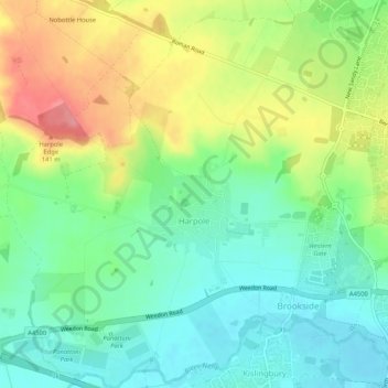
Name: Harpole topographic map, elevation, terrain.
Location: Harpole, West Northamptonshire, England, United Kingdom (52.22736 -1.01412 52.25946 -0.96177)
Average elevation: 97 m
Minimum elevation: 62 m
Maximum elevation: 154 m
Other topographic maps
Click on a map to view its topography, its elevation and its terrain.
Lower Thorpe
United Kingdom > England > West Northamptonshire > Thorpe Mandeville
Average elevation: 154 m
Ravensthorpe Reservoir
United Kingdom > England > West Northamptonshire > Coton
Average elevation: 131 m