
Make a donation
Gear up for your next adventure:
As an Amazon Associate, this site earns from qualifying purchases at no extra cost to you.
Milton topographic map
Click on the map to display elevation.
Make a donation
Gear up for your next adventure:
As an Amazon Associate, this site earns from qualifying purchases at no extra cost to you.
About this map
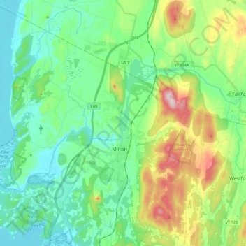
Name: Milton topographic map, elevation, terrain.
Location: Milton, Chittenden County, Vermont, 05468, United States (44.57051 -73.25628 44.72281 -73.03784)
Average elevation: 137 m
Minimum elevation: 23 m
Maximum elevation: 436 m
Make a donation
Gear up for your next adventure:
As an Amazon Associate, this site earns from qualifying purchases at no extra cost to you.
Other topographic maps
Click on a map to view its topography, its elevation and its terrain.
Heineberg Bridge Fishing Wilderness Access
United States > Vermont > Chittenden County
Average elevation: 39 m
Make a donation
Gear up for your next adventure:
As an Amazon Associate, this site earns from qualifying purchases at no extra cost to you.
Mount Mansfield
United States > Vermont > Chittenden County > Underhill
Mount Mansfield is the highest mountain in Vermont, reaching an elevation of 4,393 feet (1,339 m) above sea level. Located in the northwest of the state, it is also the highest peak in the Green Mountains. Its summit is located within the town of Underhill in Chittenden County; the ridgeline, including some…
Average elevation: 914 m
Camels Hump
United States > Vermont > Chittenden County > Huntington
The summit of Camel's Hump is home to 10 acres (4 ha) of alpine tundra vegetation. Common plants found in this area include: Bigelow's sedge (Carex bigelowii), alpine bilberry (Vaccinium uliginosum), mountain sandwort (Minuartia groenlandica), crowberry (Empetrum nigrum), mountain cranberry (Vaccinium…
Average elevation: 843 m
Make a donation
Gear up for your next adventure:
As an Amazon Associate, this site earns from qualifying purchases at no extra cost to you.
Make a donation
Gear up for your next adventure:
As an Amazon Associate, this site earns from qualifying purchases at no extra cost to you.
Camels Hump
United States > Vermont > Chittenden County > Huntington
The summit of Camel's Hump is home to 10 acres (4 ha) of alpine tundra vegetation. Common plants found in this area include: Bigelow's sedge (Carex bigelowii), alpine bilberry (Vaccinium uliginosum), mountain sandwort (Minuartia groenlandica), crowberry (Empetrum nigrum), mountain cranberry (Vaccinium…
Average elevation: 843 m
Mount Mansfield
United States > Vermont > Chittenden County > Underhill
Mount Mansfield is the highest mountain in Vermont, reaching an elevation of 4,393 feet (1,339 m) above sea level. Located in the northwest of the state, it is also the highest peak in the Green Mountains. Its summit is located within the town of Underhill in Chittenden County; the ridgeline, including some…
Average elevation: 914 m
Make a donation
Gear up for your next adventure:
As an Amazon Associate, this site earns from qualifying purchases at no extra cost to you.