
Make a donation
Gear up for your next adventure:
As an Amazon Associate, this site earns from qualifying purchases at no extra cost to you.
Salton City topographic map
Click on the map to display elevation.
Make a donation
Gear up for your next adventure:
As an Amazon Associate, this site earns from qualifying purchases at no extra cost to you.
Salton City
In the 1970s, most of the buildings constructed along the shoreline, including the city's marina were abandoned due to rising sea elevation. In the 1980s, the Imperial Irrigation District took proactive water conservation measures to reduce the flow of unused canal water into the Salton Sea. Throughout the 1980s and 1990s, as salinity and suspected pollution levels in the Salton Sea increased, the attraction of the Salton Sea as a recreational destination diminished. Most of the original tourist related structures fell during this time, including the Truckhaven Cafe, the Salton Bay Yacht Club hotel and restaurant, and the Holly House motel and restaurant (later renamed Desser House and then the Sundowner).
Make a donation
Gear up for your next adventure:
As an Amazon Associate, this site earns from qualifying purchases at no extra cost to you.
About this map
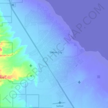
Name: Salton City topographic map, elevation, terrain.
Average elevation: -35 m
Minimum elevation: -72 m
Maximum elevation: 88 m
Make a donation
Gear up for your next adventure:
As an Amazon Associate, this site earns from qualifying purchases at no extra cost to you.
Other topographic maps
Click on a map to view its topography, its elevation and its terrain.
Make a donation
Gear up for your next adventure:
As an Amazon Associate, this site earns from qualifying purchases at no extra cost to you.