Geolocate

Province of Contumazá topographic map

Click on the map to display elevation.

About this map

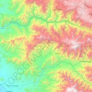
Name: Province of Contumazá topographic map, elevation, terrain.

Location: Province of Contumazá, Cajamarca, Peru (-7.66095 -79.36928 -7.17870 -78.60869)

Average elevation: 1,577 m

Minimum elevation: 61 m

Maximum elevation: 4,270 m

Other topographic maps

Click on a map to view its topography, its elevation and its terrain.

El Lirio

Peru > Cajamarca > Colasay

Average elevation: 1,585 m

Santa Cruz

Peru > Cajamarca

Average elevation: 511 m

Callancas

Peru > Cajamarca > San Pablo

Average elevation: 3,024 m

Regalado

Peru > Cajamarca > Tumbaden

Average elevation: 3,304 m

El Cardon

Peru > Cajamarca > Cutervo

Average elevation: 2,316 m

Alto Otuzco

Peru > Cajamarca > Los Baños del Inca > Otuzco

Average elevation: 2,827 m

Cruz De Chalpon

Peru > Cajamarca > San Ignacio

Average elevation: 1,488 m

Yube

Peru > Cajamarca > Callayuc

Average elevation: 1,589 m

Gear up for your next adventure:

🥾Waterproof Hiking Boots - Boots keeping your feet dry in wet conditions
🛶Kayak Accessories - Essential gear for safe and fun kayaking adventures
👖Convertible Hiking Pants - Zip-off legs to adapt to changing weather conditions
Camping Tent - Weather-resistant tents suitable for 2 to 6 people
🧴Insect Repellent - Protect yourself from bugs during outdoor adventures

As an Amazon Associate, this site earns from qualifying purchases at no extra cost to you.