
Fontana topographic map
Click on the map to display elevation.
Fontana
Most of the city of Fontana, like its eastern neighbors Rialto and San Bernardino, is built atop a geologically young, gently southward-sloping alluvial fan from nearby Lytle Creek, deposited mainly during the Holocene and late-Pleistocene epochs. There are also sedimentary deposits of similar age from Etiwanda Creek on the western edge of the city. However, the northern and southern edges of the city are formed by the much older San Gabriel and Jurupa mountain ranges, respectively. The Jurupa Mountains are composed primarily of Cretaceous and Paleozoic-era rocks, as are the San Gabriels, which also include even older, Proterozoic formations. The most prominent of the San Gabriel Mountains visible from Fontana is Cucamonga Peak, elevation 8,859 feet (2,700 m). Additionally, the Cucamonga Fault Zone, contiguous with the Sierra Madre Fault Zone, runs through the northern part of the city, along the base of the San Gabriels, notably through the Hunter's Ridge and Coyote Canyon planned communities. It is estimated to be capable of producing earthquakes approximately of magnitude 6.0-7.0.
About this map
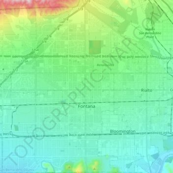
Name: Fontana topographic map, elevation, terrain.
Location: Fontana, San Bernardino County, California, United States (34.03343 -117.52432 34.18582 -117.40105)
Average elevation: 414 m
Minimum elevation: 257 m
Maximum elevation: 1,053 m
Other topographic maps
Click on a map to view its topography, its elevation and its terrain.
Big Bear City
United States > California > San Bernardino County
It is estimated that the Serrano natives first settled in Big Bear between 1,500 and 2,000 years ago. The Serranos had both winter and summer settlements throughout the area. While their winter village was located in Lucerne Valley, they relocated to villages in the San Bernardino mountains during summer, as…
Average elevation: 2,155 m
Fort Irwin
United States > California > San Bernardino County
Fort Irwin National Training Center (Fort Irwin NTC) is a major training area for the United States military in the Mojave Desert in northern San Bernardino County, California. Fort Irwin is at an average elevation of 2,454 feet (748 m). It is located 37 miles (60 km) northeast of Barstow, in the Calico…
Average elevation: 785 m
East Colton Heights
United States > California > San Bernardino County > Colton
Average elevation: 326 m
San Gorgonio Mountain
United States > California > San Bernardino County
Since it is the highest point in a region which is separated from higher peaks (e.g. in the Sierra Nevada) by relatively low terrain, San Gorgonio Mountain is one of the most topographically prominent peaks in the United States. It is ranked 7th among peaks in the 48 contiguous states and 18th overall.
Average elevation: 3,154 m
San Bernardino
United States > California > San Bernardino County > San Bernardino
Average elevation: 656 m