Geolocate

Bergenhus topographic map

Click on the map to display elevation.

About this map

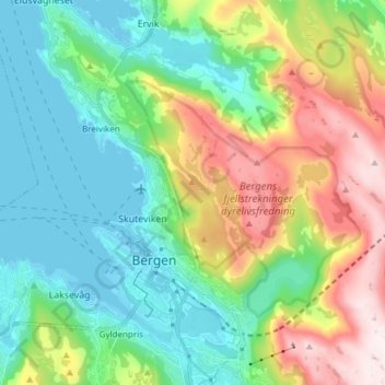
Name: Bergenhus topographic map, elevation, terrain.

Location: Bergenhus, Bergen, Vestland, Norway (60.37085 5.26111 60.44372 5.41265)

Average elevation: 210 m

Minimum elevation: -5 m

Maximum elevation: 660 m

Other topographic maps

Click on a map to view its topography, its elevation and its terrain.

Lagunen

Norway > Vestland > Bergen

Average elevation: 79 m

Strandafjellet

Norway > Vestland > Bergen

Average elevation: 122 m

Ulriken

Norway > Vestland > Bergen

Average elevation: 374 m

Tangen

Norway > Vestland > Bergen

Average elevation: 15 m

Haakonsvern

Norway > Vestland > Bergen

Average elevation: 26 m

Flatøyna

Norway > Vestland > Bergen

Average elevation: 0 m

Gear up for your next adventure:

🔭Compact Monocular - One-handed bird watching and trail spotting
🥾Trail Running Shoes - Lightweight and durable shoes for trail running
🥾Hiking Shoes - Durable and comfortable shoes for trail hiking
Lightweight Camping Tent - Portable shelter optimized for Canadian backcountry camping
🔨Vehicle Emergency Tool - Safety tool for remote road trips to trailheads

As an Amazon Associate, this site earns from qualifying purchases at no extra cost to you.