Geolocate

Strandafjellet topographic map

Click on the map to display elevation.

About this map

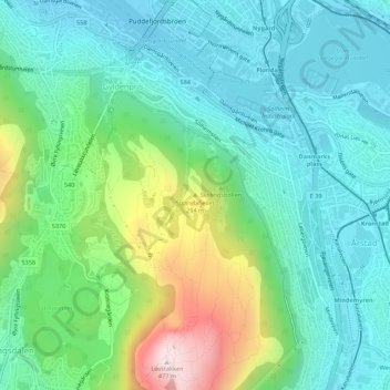
Name: Strandafjellet topographic map, elevation, terrain.

Location: Strandafjellet, Bergen, Vestland, 5057, Norway (60.37229 5.32300 60.37239 5.32310)

Average elevation: 122 m

Minimum elevation: 0 m

Maximum elevation: 471 m

Other topographic maps

Click on a map to view its topography, its elevation and its terrain.

Årstad

Norway > Vestland > Bergen

Average elevation: 184 m

Bergenhus

Norway > Vestland > Bergen

Average elevation: 210 m

Flatøyna

Norway > Vestland > Bergen

Average elevation: 0 m

Gear up for your next adventure:

Camping Coffee Maker - Brew fresh coffee anywhere on the topographic map
🛌Down Sleeping Bag - Superior warmth-to-weight ratio for cold nights
❄️Traction Ice Cleats - Slip-on spikes for icy trails and winter hiking
🌡️Emergency Mylar Blankets - Compact thermal protection for unexpected nights outdoors
🥾Waterproof Hiking Shoes - Durable shoes for wet and rugged trails

As an Amazon Associate, this site earns from qualifying purchases at no extra cost to you.