
Bornhöved topographic map
Interactive map
Click on the map to display elevation.
About this map
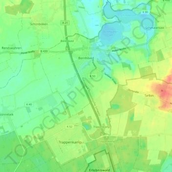
Name: Bornhöved topographic map, elevation, terrain.
Average elevation: 46 m
Minimum elevation: 26 m
Maximum elevation: 80 m
Other topographic maps
Click on a map to view its topography, its elevation and its terrain.
Kaltenkirchen
Deutschland > Schleswig-Holstein > Kreis Segeberg
Kaltenkirchen, Kreis Segeberg, Schleswig-Holstein, Deutschland
Average elevation: 32 m