
Make a donation
Gear up for your next adventure:
As an Amazon Associate, this site earns from qualifying purchases at no extra cost to you.
Meles topographic map
Click on the map to display elevation.
Make a donation
Gear up for your next adventure:
As an Amazon Associate, this site earns from qualifying purchases at no extra cost to you.
About this map
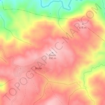
Name: Meles topographic map, elevation, terrain.
Location: Meles, Macedo de Cavaleiros, Distrito de Bragança, Portugal (41.62099 -7.05356 41.62109 -7.05346)
Average elevation: 525 m
Minimum elevation: 317 m
Maximum elevation: 632 m
Make a donation
Gear up for your next adventure:
As an Amazon Associate, this site earns from qualifying purchases at no extra cost to you.
Other topographic maps
Click on a map to view its topography, its elevation and its terrain.
Ala e Vilarinho do Monte
Portugal > Distrito de Bragança > Macedo de Cavaleiros
Average elevation: 600 m
Make a donation
Gear up for your next adventure:
As an Amazon Associate, this site earns from qualifying purchases at no extra cost to you.
Make a donation
Gear up for your next adventure:
As an Amazon Associate, this site earns from qualifying purchases at no extra cost to you.
Make a donation
Gear up for your next adventure:
As an Amazon Associate, this site earns from qualifying purchases at no extra cost to you.
Parque do Santuário de Santo Ambrósio
Portugal > Distrito de Bragança > Macedo de Cavaleiros > Vale da Porca
Average elevation: 573 m
Paisagem Protegida da Albufeira do Azibo
Portugal > Distrito de Bragança > Macedo de Cavaleiros
Average elevation: 634 m
Make a donation
Gear up for your next adventure:
As an Amazon Associate, this site earns from qualifying purchases at no extra cost to you.