
Thank you for supporting this site ❤️
Make a donation
Make a donation
Gear up for your next adventure:
As an Amazon Associate, this site earns from qualifying purchases at no extra cost to you.
Grijó topographic map
Click on the map to display elevation.
Thank you for supporting this site ❤️
Make a donation
Make a donation
Gear up for your next adventure:
As an Amazon Associate, this site earns from qualifying purchases at no extra cost to you.
About this map
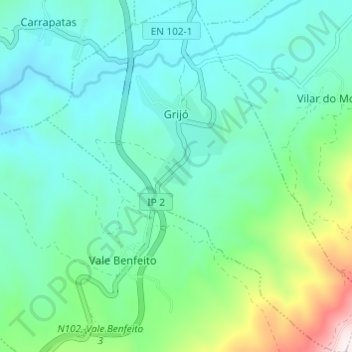
Name: Grijó topographic map, elevation, terrain.
Location: Grijó, Macedo de Cavaleiros, Bragança, Portugal (41.47173 -6.99859 41.51721 -6.94219)
Average elevation: 623 m
Minimum elevation: 478 m
Maximum elevation: 1,169 m
Thank you for supporting this site ❤️
Make a donation
Make a donation
Gear up for your next adventure:
As an Amazon Associate, this site earns from qualifying purchases at no extra cost to you.