
Aceh Besar topographic map
Interactive map
Click on the map to display elevation.
About this map
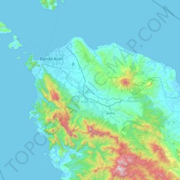
Name: Aceh Besar topographic map, elevation, terrain.
Location: Aceh Besar, Aceh, Indonesien (5.05198 95.01066 5.76461 95.84049)
Average elevation: 238 m
Minimum elevation: -3 m
Maximum elevation: 2,269 m
Other topographic maps
Click on a map to view its topography, its elevation and its terrain.
Burni Telong
Burni Telong, Timang Gajah, Bener Meriah, Aceh, Indonesien
Average elevation: 2,032 m
Geureudong
Geureudong, Gajah Putih, Bener Meriah, Aceh, Indonesien
Average elevation: 2,558 m