Geolocate

Cushing topographic map

Click on the map to display elevation.

About this map

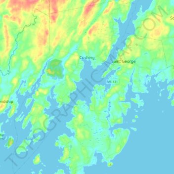
Name: Cushing topographic map, elevation, terrain.

Location: Cushing, Knox County, Maine, 04563, United States (43.92522 -69.32386 44.06587 -69.18475)

Average elevation: 13 m

Minimum elevation: -2 m

Maximum elevation: 64 m

Other topographic maps

Click on a map to view its topography, its elevation and its terrain.

Port Clyde

United States > Maine > Knox County > Saint George

Average elevation: 5 m

Mark Island

United States > Maine > Knox County > North Haven

Average elevation: 0 m

Folly Pond

United States > Maine > Knox County > Vinalhaven

Average elevation: 16 m

Gear up for your next adventure:

🥾Approach Shoes - Shoes designed for climbing approaches and rugged trails
🦌Outdoor Trail Camera - Monitor wildlife activity near your favorite spots
🥾Hiking Shorts - Breathable shorts suitable for summer hikes
💡Compact LED Flashlight - Powerful and portable flashlight for outdoor use
🎒Fully Waterproof Backpack - Total protection for photography gear and electronics

As an Amazon Associate, this site earns from qualifying purchases at no extra cost to you.