
Hopewell topographic map
Click on the map to display elevation.
About this map
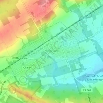
Name: Hopewell topographic map, elevation, terrain.
Location: Hopewell, Mercer County, New Jersey, 08525, United States (40.38112 -74.77742 40.39686 -74.75128)
Average elevation: 73 m
Minimum elevation: 38 m
Maximum elevation: 131 m
Other topographic maps
Click on a map to view its topography, its elevation and its terrain.
Green Curve Heights
United States > New Jersey > Mercer County > Ewing Township
Average elevation: 40 m
East Trenton Heights
United States > New Jersey > Mercer County > Hamilton Township
Average elevation: 22 m
Robbinsville
United States > New Jersey > Mercer County > Robbinsville Township
Average elevation: 32 m
Coopers Corner
United States > New Jersey > Mercer County > Hopewell Township
Average elevation: 104 m
Hillside Terrace
United States > New Jersey > Mercer County > Robbinsville Township
Average elevation: 35 m
Hamilton Square
United States > New Jersey > Mercer County > Hamilton Township
Average elevation: 29 m