
Qarnayel topographic map
Interactive map
Click on the map to display elevation.
About this map
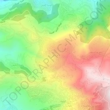
Name: Qarnayel topographic map, elevation, terrain.
Location: Qarnayel, District de Baabda, Gouvernorat du Mont Liban, Liban (33.83576 35.70757 33.87576 35.74757)
Average elevation: 1,068 m
Minimum elevation: 665 m
Maximum elevation: 1,520 m
Qornayel (parfois transcrit Qarnayel par les anglophones) (arabe. قرنايل ) est un village situé dans le caza de Baabda au Mont-Liban au Liban. Le village est situé à 35 km de Beyrouth et se situe en montagne à une altitude de 1 160 m et occupe une superficie de 848 hectares (8.48 km²).
Other topographic maps
Click on a map to view its topography, its elevation and its terrain.
Dbayeh
Liban > Gouvernorat du Mont Liban
Dbayeh, District du Metn, Gouvernorat du Mont Liban, 2502, Liban
Average elevation: 43 m
Abey
Liban > Gouvernorat du Mont Liban
Abey, District d'Aley, Gouvernorat du Mont Liban, Liban
Average elevation: 577 m
Ouadi El Karm El Matn
Liban > Gouvernorat du Mont Liban
Ouadi El Karm El Matn, District du Metn, Gouvernorat du Mont Liban, Liban
Average elevation: 1,055 m
Aramoun
Liban > Gouvernorat du Mont Liban > Aramoun
Aramoun, District d'Aley, Gouvernorat du Mont Liban, Liban
Average elevation: 478 m
Damour
Liban > Gouvernorat du Mont Liban
Damour, District du Chouf, Gouvernorat du Mont Liban, Liban
Average elevation: 87 m
Beit Mery
Liban > Gouvernorat du Mont Liban
Beit Mery, District du Metn, Gouvernorat du Mont Liban, Liban
Average elevation: 447 m