
Damour topographic map
Interactive map
Click on the map to display elevation.
About this map
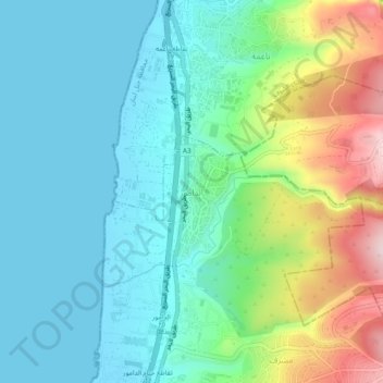
Name: Damour topographic map, elevation, terrain.
Location: Damour, District du Chouf, Gouvernorat du Mont Liban, Liban (33.71076 35.43548 33.75076 35.47548)
Average elevation: 87 m
Minimum elevation: 0 m
Maximum elevation: 331 m
Other topographic maps
Click on a map to view its topography, its elevation and its terrain.
Dbayeh
Liban > Gouvernorat du Mont Liban
Dbayeh, District du Metn, Gouvernorat du Mont Liban, 2502, Liban
Average elevation: 43 m
Abey
Liban > Gouvernorat du Mont Liban
Abey, District d'Aley, Gouvernorat du Mont Liban, Liban
Average elevation: 577 m
Ouadi El Karm El Matn
Liban > Gouvernorat du Mont Liban
Ouadi El Karm El Matn, District du Metn, Gouvernorat du Mont Liban, Liban
Average elevation: 1,055 m
Qarnayel
Liban > Gouvernorat du Mont Liban
Qarnayel, District de Baabda, Gouvernorat du Mont Liban, Liban
Average elevation: 1,068 m
Aramoun
Liban > Gouvernorat du Mont Liban > Aramoun
Aramoun, District d'Aley, Gouvernorat du Mont Liban, Liban
Average elevation: 478 m
Beit Mery
Liban > Gouvernorat du Mont Liban
Beit Mery, District du Metn, Gouvernorat du Mont Liban, Liban
Average elevation: 447 m