Geolocate

Upwey topographic map

Click on the map to display elevation.

About this map

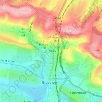
Name: Upwey topographic map, elevation, terrain.

Location: Upwey, Weymouth, Dorset, England, DT3 5QG, United Kingdom (50.64262 -2.48943 50.68262 -2.44943)

Average elevation: 78 m

Minimum elevation: 11 m

Maximum elevation: 168 m

Other topographic maps

Click on a map to view its topography, its elevation and its terrain.

Weymouth Bay

United Kingdom > England > Dorset > Weymouth > Preston

Average elevation: 3 m

Gear up for your next adventure:

📷Outdoor Action Camera - Capture high-elevation views and rugged adventures
🥾Waterproof Hiking Boots - Boots keeping your feet dry in wet conditions
👟Sport Hiking Sandals - Breathable footwear for water crossings and camp rest
🛌Insulated Sleeping Pad - Critical thermal barrier between you and the cold ground
🏕️Camping Hammock - Integrated protection for sleeping between trees

As an Amazon Associate, this site earns from qualifying purchases at no extra cost to you.