Geolocate

Shotwick topographic map

Click on the map to display elevation.

About this map

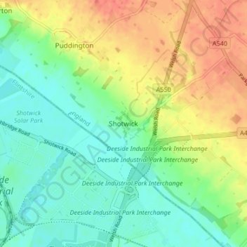
Name: Shotwick topographic map, elevation, terrain.

Location: Shotwick, Cheshire West and Chester, England, CH1 6HZ, United Kingdom (53.22025 -3.01587 53.26025 -2.97587)

Average elevation: 20 m

Minimum elevation: 0 m

Maximum elevation: 48 m

Other topographic maps

Click on a map to view its topography, its elevation and its terrain.

Gear up for your next adventure:

🧴Insect Repellent - Protect yourself from bugs during outdoor adventures
🥾Trail Hiking Boots - Supportive boots for rough trails
🛏️Sleeping Bag - Warm and compact sleeping bags for outdoor camping
🥾Mountaineering Boots - Supportive boots for climbing and high-altitude hiking
🚲Bike Repair Kit - Essential tools for on-trail mechanical issues

As an Amazon Associate, this site earns from qualifying purchases at no extra cost to you.