
Willington topographic map
Click on the map to display elevation.
About this map
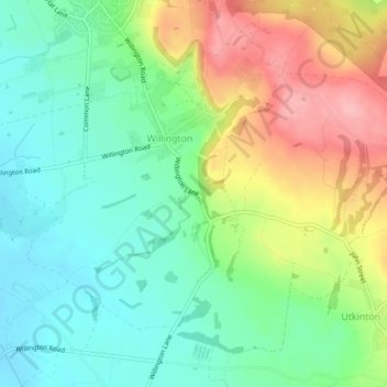
Name: Willington topographic map, elevation, terrain.
Location: Willington, Cheshire West and Chester, England, United Kingdom (53.18087 -2.72016 53.20309 -2.67533)
Average elevation: 86 m
Minimum elevation: 34 m
Maximum elevation: 174 m
Other topographic maps
Click on a map to view its topography, its elevation and its terrain.
Little Stanney Wood
United Kingdom > England > Cheshire West and Chester > Stoak > Little Stanney
Average elevation: 11 m