
Make a donation
Gear up for your next adventure:
As an Amazon Associate, this site earns from qualifying purchases at no extra cost to you.
Leeds and Grenville topographic map
Click on the map to display elevation.
Make a donation
Gear up for your next adventure:
As an Amazon Associate, this site earns from qualifying purchases at no extra cost to you.
About this map
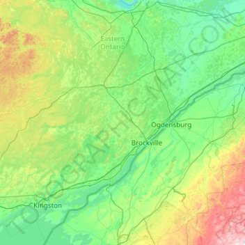
Name: Leeds and Grenville topographic map, elevation, terrain.
Average elevation: 146 m
Minimum elevation: 50 m
Maximum elevation: 704 m
Leeds and Grenville Counties trails, hiking, mountain biking, running and outdoor activities
Make a donation
Gear up for your next adventure:
As an Amazon Associate, this site earns from qualifying purchases at no extra cost to you.
Other topographic maps
Click on a map to view its topography, its elevation and its terrain.
Make a donation
Gear up for your next adventure:
As an Amazon Associate, this site earns from qualifying purchases at no extra cost to you.
Rideau River
Canada > Ontario > Leeds and Grenville Counties > Merrickville > Merrickville-Wolford
Average elevation: 109 m
Elizabethtown
Canada > Ontario > Leeds and Grenville Counties > Elizabethtown-Kitley
Average elevation: 110 m
Make a donation
Gear up for your next adventure:
As an Amazon Associate, this site earns from qualifying purchases at no extra cost to you.
Leeds and the Thousand Islands
Canada > Ontario > Leeds and Grenville Counties
Average elevation: 102 m
Whitefish Lake
Canada > Ontario > Leeds and Grenville Counties > Rideau Lakes
Average elevation: 122 m
Little Crosby Lake
Canada > Ontario > Leeds and Grenville Counties > Rideau Lakes
Average elevation: 166 m
Make a donation
Gear up for your next adventure:
As an Amazon Associate, this site earns from qualifying purchases at no extra cost to you.
Edwardsburgh
Canada > Ontario > Leeds and Grenville Counties > Edwardsburgh/Cardinal
Average elevation: 92 m
Wolford
Canada > Ontario > Leeds and Grenville Counties > Merrickville-Wolford
Average elevation: 113 m
Charleston Lake
Canada > Ontario > Leeds and Grenville Counties > Leeds and the Thousand Islands > Outlet
Average elevation: 103 m
Make a donation
Gear up for your next adventure:
As an Amazon Associate, this site earns from qualifying purchases at no extra cost to you.
Oxford-on-Rideau
Canada > Ontario > Leeds and Grenville Counties > North Grenville
Average elevation: 103 m
Upper Rideau Lake
Canada > Ontario > Leeds and Grenville Counties > Rideau Lakes > Newboro
Average elevation: 148 m
Thousand Islands National Park
Canada > Ontario > Leeds and Grenville Counties > Leeds and the Thousand Islands > Rockport
Average elevation: 116 m
Make a donation
Gear up for your next adventure:
As an Amazon Associate, this site earns from qualifying purchases at no extra cost to you.
Gananoque Lake
Canada > Ontario > Leeds and Grenville Counties > Leeds and the Thousand Islands
Average elevation: 92 m
Spectacle Lake
Canada > Ontario > Leeds and Grenville Counties > Rideau Lakes
Average elevation: 189 m
Leeds
Canada > Ontario > Leeds and Grenville Counties > Leeds and the Thousand Islands
Average elevation: 104 m
Make a donation
Gear up for your next adventure:
As an Amazon Associate, this site earns from qualifying purchases at no extra cost to you.
Codfish Island
Canada > Ontario > Leeds and Grenville Counties > Leeds and the Thousand Islands
Average elevation: 79 m
Why Island
Canada > Ontario > Leeds and Grenville Counties > Leeds and the Thousand Islands
Average elevation: 92 m
Leeds
Canada > Ontario > Leeds and Grenville Counties > Leeds and the Thousand Islands
Average elevation: 104 m
Make a donation
Gear up for your next adventure:
As an Amazon Associate, this site earns from qualifying purchases at no extra cost to you.
Make a donation
Gear up for your next adventure:
As an Amazon Associate, this site earns from qualifying purchases at no extra cost to you.