
Make a donation
Gear up for your next adventure:
As an Amazon Associate, this site earns from qualifying purchases at no extra cost to you.
Spiegelwaal topographic map
Click on the map to display elevation.
Make a donation
Gear up for your next adventure:
As an Amazon Associate, this site earns from qualifying purchases at no extra cost to you.
Spiegelwaal
De Spiegelwaal is een nevengeul van ongeveer 4 kilometer in de Waal ter hoogte van Nijmegen.
Make a donation
Gear up for your next adventure:
As an Amazon Associate, this site earns from qualifying purchases at no extra cost to you.
About this map
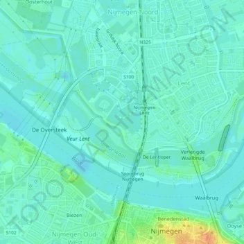
Name: Spiegelwaal topographic map, elevation, terrain.
Location: Spiegelwaal, Nijmegen, Gelderland, Nederland (51.85549 5.83414 51.86440 5.87971)
Average elevation: 12 m
Minimum elevation: 4 m
Maximum elevation: 42 m
Make a donation
Gear up for your next adventure:
As an Amazon Associate, this site earns from qualifying purchases at no extra cost to you.
Other topographic maps
Click on a map to view its topography, its elevation and its terrain.
Make a donation
Gear up for your next adventure:
As an Amazon Associate, this site earns from qualifying purchases at no extra cost to you.