
Dietersheim topographic map
Click on the map to display elevation.
About this map
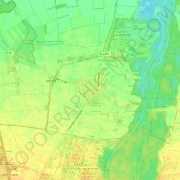
Name: Dietersheim topographic map, elevation, terrain.
Average elevation: 471 m
Minimum elevation: 456 m
Maximum elevation: 480 m
Other topographic maps
Click on a map to view its topography, its elevation and its terrain.
Moosburg
Germany > Bavaria > Landkreis Freising
The oldest town between Regensburg and Italy lies on the river Isar at an altitude of 421 m (1381 ft). It has 20,237 inhabitants (2022) and covers an area of 44 km2. It is easily reached by the A 92 autobahn and regional trains on the Munich–Regensburg line. Furthermore, it takes just 20 minutes to get to…
Average elevation: 428 m
Moosburg
Germany > Bavaria > Landkreis Freising
The oldest town between Regensburg and Italy, it lies on the river Isar at an altitude of 421 m (1381 ft). It has 20,237 inhabitants (2022) and covers an area of 44 km2. It is easily reached by the A 92 autobahn and regional trains on the Munich–Regensburg line. Furthermore, it takes just 20 minutes to get…
Average elevation: 428 m
85413
Germany > Bavaria > Landkreis Freising > Margarethenried > Sixt in der Point
Average elevation: 484 m
Moosburg
Germany > Bavaria > Landkreis Freising
The oldest town between Regensburg and Italy, it lies on the river Isar at an altitude of 421 m (1381 ft). It has 20,237 inhabitants (2022) and covers an area of 44 km2. It is easily reached by the A 92 autobahn and regional trains on the Munich–Regensburg line. Furthermore, it takes just 20 minutes to get…
Average elevation: 428 m