
Make a donation
Gear up for your next adventure:
As an Amazon Associate, this site earns from qualifying purchases at no extra cost to you.
Valensole topographic map
Click on the map to display elevation.
Make a donation
Gear up for your next adventure:
As an Amazon Associate, this site earns from qualifying purchases at no extra cost to you.
About this map
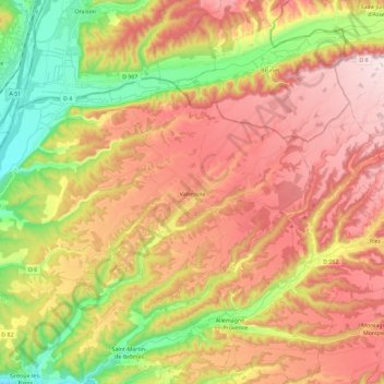
Name: Valensole topographic map, elevation, terrain.
Average elevation: 518 m
Minimum elevation: 300 m
Maximum elevation: 713 m
Make a donation
Gear up for your next adventure:
As an Amazon Associate, this site earns from qualifying purchases at no extra cost to you.
Other topographic maps
Click on a map to view its topography, its elevation and its terrain.
Cheiron
Frankrijk > Provence-Alpes-Côte d'Azur > Alpes-de-Haute-Provence > Castellane
Average elevation: 1,015 m
Charembeau
Frankrijk > Provence-Alpes-Côte d'Azur > Alpes-de-Haute-Provence > Forcalquier
Average elevation: 487 m
Saint-Michel
Frankrijk > Provence-Alpes-Côte d'Azur > Alpes-de-Haute-Provence > Moustiers-Sainte-Marie
Average elevation: 731 m
Make a donation
Gear up for your next adventure:
As an Amazon Associate, this site earns from qualifying purchases at no extra cost to you.
Haut Rioclar
Frankrijk > Provence-Alpes-Côte d'Azur > Alpes-de-Haute-Provence > Méolans-Revel
Average elevation: 1,405 m
Le Pont de l'Estrech
Frankrijk > Provence-Alpes-Côte d'Azur > Alpes-de-Haute-Provence > Les Prats
Average elevation: 1,809 m
Gaudeissard
Frankrijk > Provence-Alpes-Côte d'Azur > Alpes-de-Haute-Provence > Méolans-Revel
Average elevation: 1,429 m
La Pierre de l'Aigle
Frankrijk > Provence-Alpes-Côte d'Azur > Alpes-de-Haute-Provence > Ubaye-Serre-Ponçon
Average elevation: 1,065 m
Make a donation
Gear up for your next adventure:
As an Amazon Associate, this site earns from qualifying purchases at no extra cost to you.
La Croisette
Frankrijk > Provence-Alpes-Côte d'Azur > Alpes-de-Haute-Provence > Barcelonnette
Average elevation: 1,297 m
Les Grangettes
Frankrijk > Provence-Alpes-Côte d'Azur > Alpes-de-Haute-Provence > Montclar
Average elevation: 1,315 m
Colmars
Frankrijk > Provence-Alpes-Côte d'Azur > Alpes-de-Haute-Provence > Colmars > Colmars
Average elevation: 1,565 m
Molanès
Frankrijk > Provence-Alpes-Côte d'Azur > Alpes-de-Haute-Provence > Uvernet-Fours
Average elevation: 1,566 m
Make a donation
Gear up for your next adventure:
As an Amazon Associate, this site earns from qualifying purchases at no extra cost to you.