
Kingston topographic map
Click on the map to display elevation.
About this map
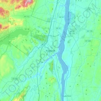
Name: Kingston topographic map, elevation, terrain.
Average elevation: 125 m
Minimum elevation: -7 m
Maximum elevation: 938 m
Other topographic maps
Click on a map to view its topography, its elevation and its terrain.
Village of Ellenville
United States > New York > Ulster County > Town of Wawarsing
Average elevation: 325 m
Phoenicia
United States > New York > Ulster County > Town of Shandaken > Phoenicia
Average elevation: 349 m
Town of Denning
United States > New York > Ulster County
The town is in the Catskill Mountains and borders Sullivan County, New York. It is rugged and heavily wooded. Most settlement is concentrated around the hamlet of Sundown on Rondout Creek, along the two branches of the Neversink River or in the plateau between the two valleys northeast of Red Hill, at…
Average elevation: 663 m
Minnewaska State Park Preserve
United States > New York > Ulster County > Town of Wawarsing
Average elevation: 279 m
Catskills Visitor Center
United States > New York > Ulster County > Town of Shandaken > Beechford
Average elevation: 301 m
Village of Ellenville
United States > New York > Ulster County > Town of Wawarsing
Average elevation: 325 m
Town of Shandaken
United States > New York > Ulster County
The town is inside the Catskill Park, and is entirely mountainous. Within it lies Slide Mountain, the Catskill Mountains' highest peak at 4,180 ft (1,270 m), and several of the other Catskill High Peaks over 3,500 ft (1,100 m) in elevation.
Average elevation: 652 m
Village of Ellenville
United States > New York > Ulster County > Town of Wawarsing
Average elevation: 325 m
Village of Ellenville
United States > New York > Ulster County > Town of Wawarsing
Average elevation: 325 m
Gardiner
United States > New York > Ulster County > Town of Gardiner > Gardiner
Average elevation: 101 m
Catskills Visitor Center
United States > New York > Ulster County > Town of Shandaken > Beechford
Average elevation: 301 m
Cooper Lake
United States > New York > Ulster County > Town of Woodstock > Lake Hill
Average elevation: 367 m
Woodland Valley Campground
United States > New York > Ulster County > Town of Shandaken
Average elevation: 565 m
Town of Denning
United States > New York > Ulster County
The town is in the Catskill Mountains and borders Sullivan County, New York. It is rugged and heavily wooded. Most settlement is concentrated around the hamlet of Sundown on Rondout Creek, along the two branches of the Neversink River or in the plateau between the two valleys northeast of Red Hill, at…
Average elevation: 663 m