
Town of Shawangunk topographic map
Interactive map
Click on the map to display elevation.
About this map
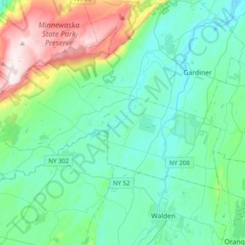
Name: Town of Shawangunk topographic map, elevation, terrain.
Location: Town of Shawangunk, Ulster County, New York, United States (41.58235 -74.39527 41.69347 -74.12452)
Average elevation: 204 m
Minimum elevation: 57 m
Maximum elevation: 695 m
Other topographic maps
Click on a map to view its topography, its elevation and its terrain.
Woodland Valley Campground
United States > New York > Ulster County > Town of Shandaken
Woodland Valley Campground, Town of Shandaken, Ulster County, New York, United States
Average elevation: 565 m
Rutsonville
United States > New York > Ulster County > Town of Gardiner
Rutsonville, Town of Gardiner, Ulster County, New York, United States
Average elevation: 149 m
Frost Valley
United States > New York > Ulster County
Frost Valley, Town of Denning, Ulster County, New York, United States
Average elevation: 735 m
City of Kingston
United States > New York > Ulster County
City of Kingston, Ulster County, New York, 12401, United States
Average elevation: 52 m
Town of Marbletown
United States > New York > Ulster County
Town of Marbletown, Ulster County, New York, United States
Average elevation: 126 m
Eagle Mountain
United States > New York > Ulster County
Eagle Mountain, Ulster County, New York, United States
Average elevation: 893 m
Bloomington
United States > New York > Ulster County > Town of Rosendale
Bloomington, Town of Rosendale, Ulster County, New York, 12411, United States
Average elevation: 61 m
Seager
United States > New York > Ulster County
Seager, Town of Hardenburgh, Ulster County, New York, United States
Average elevation: 760 m
Mount Tobias
United States > New York > Ulster County > Town of Woodstock
Mount Tobias, Town of Woodstock, Ulster County, New York, 12495, United States
Average elevation: 513 m
Accord
United States > New York > Ulster County
Accord, Town of Rochester, Ulster County, New York, United States
Average elevation: 94 m
Wilbur
United States > New York > Ulster County > City of Kingston
Wilbur, City of Kingston, Ulster County, New York, 12417, United States
Average elevation: 54 m
Wittenberg
United States > New York > Ulster County > Town of Woodstock
Wittenberg, Town of Woodstock, Ulster County, New York, 12409, United States
Average elevation: 352 m
Veteran
United States > New York > Ulster County > Town of Saugerties
Veteran, Town of Saugerties, Ulster County, New York, 12477, United States
Average elevation: 88 m
Town of Plattekill
United States > New York > Ulster County
Town of Plattekill, Ulster County, New York, United States
Average elevation: 162 m
Minnewaska State Park Preserve
United States > New York > Ulster County > Town of Wawarsing
Minnewaska State Park Preserve, Town of Wawarsing, Town of Shawangunk, Ulster County, New York, United States
Average elevation: 279 m
Village of Ellenville
United States > New York > Ulster County > Town of Wawarsing
Village of Ellenville, Town of Wawarsing, Ulster County, New York, United States
Average elevation: 325 m
Town of Woodstock
United States > New York > Ulster County
Town of Woodstock, Ulster County, New York, United States
Average elevation: 332 m
Town of Esopus
United States > New York > Ulster County
Town of Esopus, Ulster County, New York, United States
Average elevation: 79 m
Town of Hurley
United States > New York > Ulster County
Town of Hurley, Ulster County, New York, United States
Average elevation: 123 m
Town of Wawarsing
United States > New York > Ulster County
Town of Wawarsing, Ulster County, New York, United States
Average elevation: 347 m
Town of New Paltz
United States > New York > Ulster County
Town of New Paltz, Ulster County, New York, 12561, United States
Average elevation: 123 m
Graham Mountain
United States > New York > Ulster County
Graham Mountain, Ulster County, New York, United States
Average elevation: 916 m
Rondout
United States > New York > Ulster County > City of Kingston > Rondout
Rondout, City of Kingston, Ulster County, New York, 12466, United States
Average elevation: 35 m
Greenfield Park
United States > New York > Ulster County > Town of Wawarsing
Greenfield Park, Town of Wawarsing, Ulster County, New York, 12435, United States
Average elevation: 331 m
Glasco
United States > New York > Ulster County
Glasco, Town of Saugerties, Ulster County, New York, 12432, United States
Average elevation: 35 m
Town of Denning
United States > New York > Ulster County
Town of Denning, Ulster County, New York, United States
Average elevation: 657 m
Phoenicia
United States > New York > Ulster County > Town of Shandaken
Phoenicia, Town of Shandaken, Ulster County, New York, United States
Average elevation: 349 m
Hurley
United States > New York > Ulster County
Hurley, Town of Hurley, Ulster County, New York, United States
Average elevation: 80 m
Woodstock
United States > New York > Ulster County > Woodstock
Woodstock, Town of Woodstock, Ulster County, New York, 12498, United States
Average elevation: 248 m
Rocky Mountain
United States > New York > Ulster County > Town of Shandaken
Rocky Mountain, Town of Shandaken, Ulster County, New York, United States
Average elevation: 924 m
Catskills Visitor Center
United States > New York > Ulster County > Town of Shandaken > Beechford
Catskills Visitor Center, Beechford, Town of Shandaken, Ulster County, New York, United States
Average elevation: 301 m
Kerhonkson
United States > New York > Ulster County > Town of Wawarsing
Kerhonkson, Town of Wawarsing, Ulster County, New York, United States
Average elevation: 167 m
Mount Tremper
United States > New York > Ulster County > Town of Shandaken
Mount Tremper, Town of Shandaken, Ulster County, New York, 12457, United States
Average elevation: 343 m
Village of New Paltz
United States > New York > Ulster County > Town of New Paltz
Village of New Paltz, Town of New Paltz, Ulster County, New York, 12561, United States
Average elevation: 84 m
Shokan
United States > New York > Ulster County
Shokan, Town of Olive, Ulster County, New York, 12481, United States
Average elevation: 296 m