Geolocate

Acoria topographic map

Click on the map to display elevation.

About this map

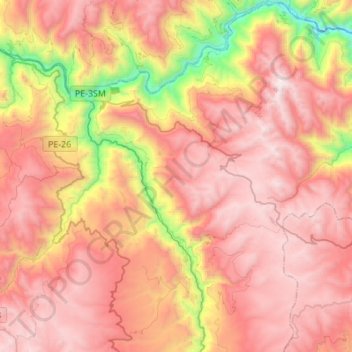
Name: Acoria topographic map, elevation, terrain.

Location: Acoria, Province of Huancavelica, Huancavelica, Peru (-12.72744 -74.95739 -12.46353 -74.68380)

Average elevation: 3,885 m

Minimum elevation: 2,624 m

Maximum elevation: 4,731 m

Other topographic maps

Click on a map to view its topography, its elevation and its terrain.

Caymo

Peru > Huancavelica > Salcabamba

Average elevation: 3,119 m

Palermo

Peru > Huancavelica > El Carmen

Average elevation: 3,708 m

Los Andes

Peru > Huancavelica

Average elevation: 4,171 m

Yanacocha

Peru > Huancavelica

Average elevation: 3,468 m

Gear up for your next adventure:

🥾Approach Shoes - Shoes designed for climbing approaches and rugged trails
🦟Insect Repellent - Keep mosquitoes and black flies away in wooded areas
🌡️Emergency Mylar Blankets - Compact thermal protection for unexpected nights outdoors
Camping Groundsheet - Protect your tent from moisture and dirt
🧥Insulated Jacket - Keep warm in cold outdoor conditions

As an Amazon Associate, this site earns from qualifying purchases at no extra cost to you.